Aerial & Lidar Survey
Elevate your data, elevate your insight!
PC Surveying Services a Surveytech Company now offers drones and lidar based solutions. We offer a wide range of benefits and has diverse applications, making it a valuable tool in various fields.
Why Choose Us?
Expertise and Experience
Specialized Knowledge
Our team comprises professionals with extensive knowledge and experience in various surveying fields, ensuring expert guidance and precision in data collection and analysis.
Proven Track Record
We have successfully completed projects, demonstrating our capability and reliability in delivering high-quality surveying services.
Cutting-Edge Equipment
We utilize the latest in surveying technology, including drone and LiDAR systems, to provide accurate and high-resolution data.
Efficiency and Timesaving
Drones can cover large areas in a short amount of time compared to traditional surveying methods. This speed can significantly reduce the time it takes to gather data.
High-Quality Data
Drones equipped with high-resolution cameras and sensors, such as LiDAR, can capture detailed images and 3D maps. This high-quality data is invaluable for accurate analysis and decision-making.
Flexibility and Versatility
Drones can be deployed in a variety of environments, from urban areas to remote wilderness, making them versatile tools for different types of surveying needs.
Real-time Data and Analysis
Drones can offer real-time data transmission, allowing for immediate analysis and decision-making, which is crucial in time-sensitive projects.
Industries we serve
1. Land and Topographic Surveying
Drones are used to create detailed topographical maps, helping in planning and design for construction, landscaping, and other projects.
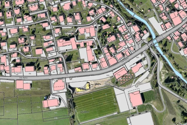
Cadastral map overlayed on aerial images
After post-processing with a photogrammetry software, these same images can produce very detailed elevation models, contour lines and breaklines, as well as 3D reconstructions of land sites or buildings.
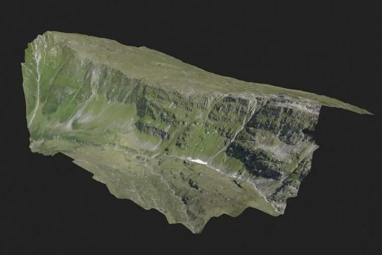
Survey of a remote mountain
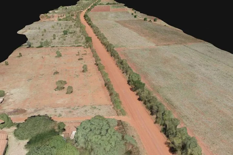
Survey of a road before construction planning
These images also provide the foundation for detailed models of site topography for pre-construction engineering studies. The generated data can also be transferred to any CAD or BIM software so that engineers can immediately start working from a 3D model.
As data collection by drones is easily repeatable at low cost, images can be taken at regular intervals and overlaid on the original blueprints to assess whether the construction work is moving according to plan specifications.
2. Construction Site Monitoring
Drones monitor construction progress, ensuring that projects are on schedule and identifying potential issues early on.
-
Digital Modeling
Generate contour lines and orthomosaics
-
Output
Create high-accuracy maps in any coordinate system
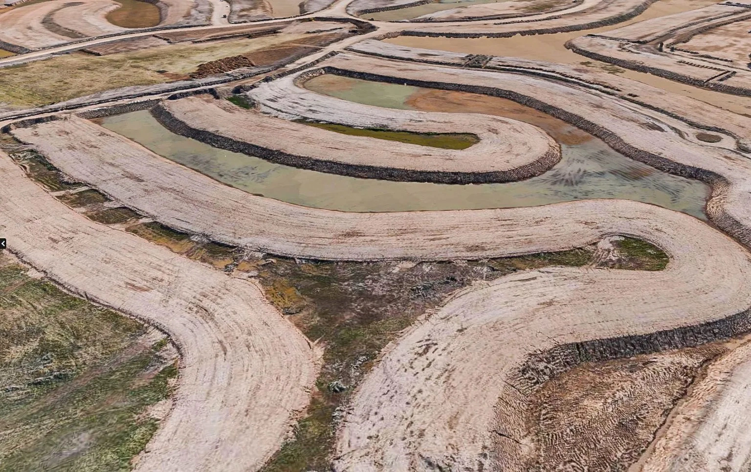
Survey your whole construction site in one morning and get accurate info just hours later. Use the extra time for in-depth inspection of a lifelike, detailed map that drives smarter decisions. The vivid colors and sharp contrasts allow for quick detection of changes and materials at a glance.
3. Agriculture
In agriculture, drones assess crop health, monitor irrigation, and manage resources efficiently by providing detailed aerial views of farmlands.
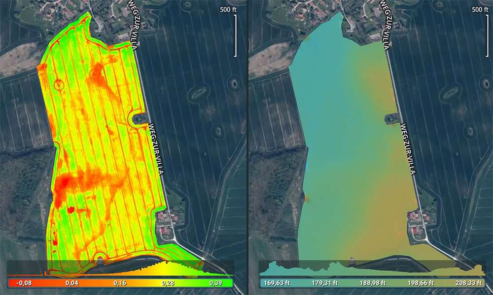
Topography of fields from multispectral or RGB imagery guides drainage and irragation planning. Using Pix4D and Micasense Multispectral Payload.
Irragation monitoring and planning
Use drone maps, digital surface models, and terrain models for irrigation and drainage management. Multispectral data can also help identify leaky irrigation pipes or areas that need more water.
-
RGB Color Orthomosaic
a color orthomosaic map is often the first step in scouting. Interpretation is intuitive and can be used to easily detect gaps in the crop and find areas of visible stress while visualizing maturity and growth stages.
-
Multispectra Data Outputs
in the form of vegetation index maps can help identify problems in a field
-
Digital Surface Models (DSM)
digital representations of the elevation of the field and crop. They can be used for irrigation planning, water flow analysis, and crop optimization based on slope direction.
-
Multispectral data
can also be visualized as combinations of three bands, assigning a band to the red, green, and blue colors. This Visualization maintains texture and context and reveals hidden patterns, such as the presence of weeds or water-logged soil.